DRONE SERVICE
DRONE SERVICE

Professional Thermal Drone Services
We use advanced thermal imaging and powerful zoom cameras to find lost pets, recover downed game, and monitor property—day or night, even in thick cover.
Northeast Ohio's Leading Experts in thermal drone search, recovery and services.
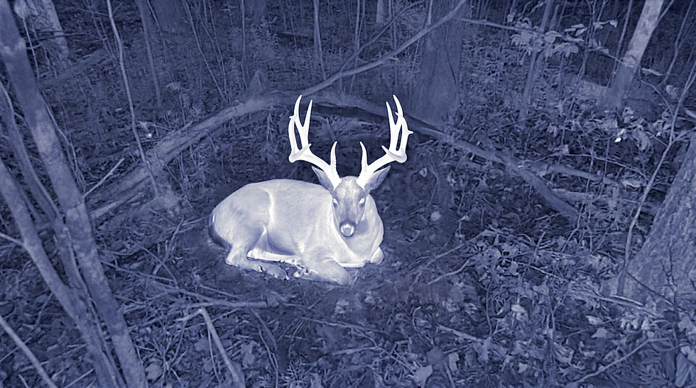
Deer Recovery – find the buck you worked for
As fellow hunters, we use advanced thermal drones to eliminate the agonizing doubt after a shot by quickly locating your deer, even in thick brush or total darkness. This allows you to ensure an ethical recovery and cover massive ground in minutes, all while minimizing foot traffic and pressure on your property.
%20%D0%BA%D0%BE%D0%BF%D0%B8%D1%8F.png)

Pet Search & Recovery – because they’re family
When your pet goes missing, we know you're searching for a family member, which is why we treat every search with urgency and care. We use gentle, low-stress thermal drones to quickly spot their heat signature from the sky, keeping you constantly updated and supported so you never search alone.
Professional Thermal Drone Services
We use advanced thermal imaging and powerful zoom cameras to find lost pets, recover downed game, and monitor property -day or night, even in thick cover.
Northeast Ohio's Leading Experts in thermal drone search, recovery and services.
Livestock Search – protect your herd and your hard work
We know that loose livestock puts your livelihood and years of hard work at risk, which is why our thermal drones quickly scan massive pastures, deep ravines, and thick woods you can't see from a road. We send exact location pins and photos straight to your phone, allowing you and your team to bring every animal home safely and efficiently.


Predator Monitoring – see the threats you can’t
Predators move in the dark when your animals are most vulnerable, but our thermal drones eliminate the guesswork by safely tracking their nighttime activity around your property. We map exact travel routes and bedding areas, giving you the crucial pattern data needed to adjust fencing, lighting, or hunting and trapping plans.
Deer Recovery – find the buck you worked for
As fellow hunters, we use advanced thermal drones to eliminate the agonizing doubt after a shot by quickly locating your deer, even in thick brush or total darkness. This allows you to ensure an ethical recovery and cover massive ground in minutes, all while minimizing foot traffic and pressure on your property.
Pet Search & Recovery – because they’re family
When your pet goes missing, we know you're searching for a family member, which is why we treat every search with urgency and care. We use gentle, low-stress thermal drones to quickly spot their heat signature from the sky, keeping you constantly updated and supported so you never search alone.
Real‑estate Photos & Video – show the whole story of your property
Online buyers scroll fast, so we provide high-quality aerial photos and videos that instantly tell the full story of your home, land, and outbuildings in a way ground shots never could. We deliver edited, MLS-ready media that perfectly highlights farms, hunting land, and rural properties, allowing buyers to see exactly how everything fits together before they ever visit.

Livestock Search – protect your herd and your hard work
We know that loose livestock puts your livelihood and years of hard work at risk, which is why our thermal drones quickly scan massive pastures, deep ravines, and thick woods you can't see from a road. We send exact location pins and photos straight to your phone, allowing you and your team to bring every animal home safely and efficiently.
Predator Monitoring – see the threats you can’t
Predators move in the dark when your animals are most vulnerable, but our thermal drones eliminate the guesswork by safely tracking their nighttime activity around your property. We map exact travel routes and bedding areas, giving you the crucial pattern data needed to adjust fencing, lighting, or hunting and trapping plans.
We are your local drone technology experts. Based in the Medina area, Racks & Tails Drone Service proudly serves the greater Northeast Ohio region.
Real‑estate Photos & Video – show the whole story of your property
Online buyers scroll fast, so we provide high-quality aerial photos and videos that instantly tell the full story of your home, land, and outbuildings in a way ground shots never could. We deliver edited, MLS-ready media that perfectly highlights farms, hunting land, and rural properties, allowing buyers to see exactly how everything fits together before they ever visit.